We have all been there, a new body of water, and it’s huge. No idea if the fish are eating, what the fish are eating, or even where to start. Or perhaps it's a body of water you have been fishing for years and just want a different way to look at and approach it. My goal today is to help you break it down a bit and have the best success possible. Today, I will be looking at Clear Lake in California. I’ve never fished Clear Lake, but I want to use it as a model to help us look at and break down a body of water. Today I’ll be looking at this lake for the first time and I will show you how I would divide it up to get the best chances possible to be successful.
Step 1: Looking at Nautical Charts
First order of business is to open up Google Maps as well as a secondary mapping software if you have access to one. i Boating: GPS Nautical Charts is free. I tend to gravitate more towards Navionics for this particular type of research. This should be what you are looking at when you first dive in.
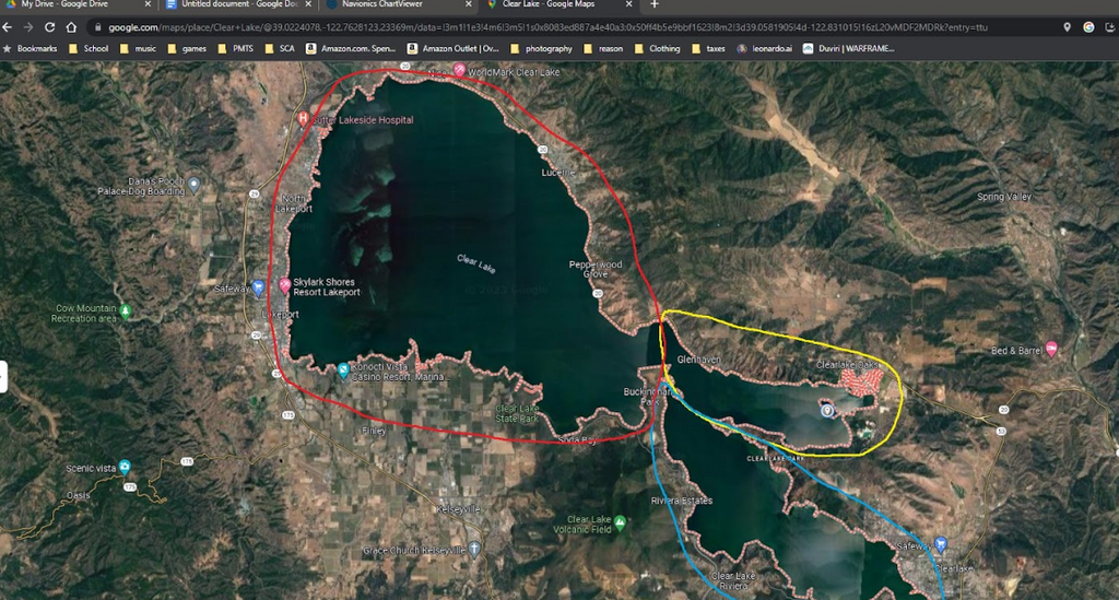
The first thing i like to look at is the satellite view and i start to break the body of water down into smaller more manageable areas like so.
What I have effectively done is break this large body of water down into three separate sections based on the natural geography of the lake. Next we are going to zoom into the section I circled in yellow and take a closer look at both satellite and Navionics to start pinpointing areas that look like they could be productive. Upon zooming in closer I noticed the yellow section can actually be broken up further into additional areas. I would treat the area to the northeast of “Rattlesnake Island” as its own separate entity. Here is a closer look. Now let’s begin to break this area down.


Looking at this particular area we can see that there is a very large residential area with a lot of docks. There are also a-lot of great looking vegetation covered banks in the body of water NE of Rattlesnake Island with several small submerged islands and some good looking ledges, all sitting in less than 30 feet of water.
Step 2: Develop a float plan
From here I would start to develop my float plan and figure out where to start and end the day. Large bodies of water can never be fully fished in a single day, therefore you will have to pick and choose the areas that look the most promising for fish to find cover, all while considering where you will get into and off of the body of water. Utilizing Google Maps can really help you get an idea of how to access a body of water. Find a launch point that will allow you to fish the area you’d like without spending your entire day paddling or pedaling.
I absolutely love fishing docks, so this residential area would most likely be a focus for me for at least one day if not several. You could probably spend an entire day just picking apart these docks and never hit the more open section outside of it.
One hazard of larger bodies of water is that they tend to get very windy and the water can get choppy. When that happens I tend to steer clear of very large open areas like I circled in RED. Those areas will be a nightmare to try and fish in a kayak and will be dangerous when water starts to produce whitecaps that big water is prone to do. Keep that in mind, wear your life jacket and stay safe!
Doing research on the water you will be fishing is paramount to being successful whether you are a tournament angler or just someone who is doing it for the love of the sport. So get on your computer, tablet or phone and start breaking water down and zooming into areas to find those spots that will be productive throughout the day.
Written by Kyle Matlock, Feelfree Pros Staff Team Member
Edited by Bobby Ulrich, Feelfree Pro Staff Team Member
-------------------------------------------------------------------------------------------